Code: 54856
Date: 1579
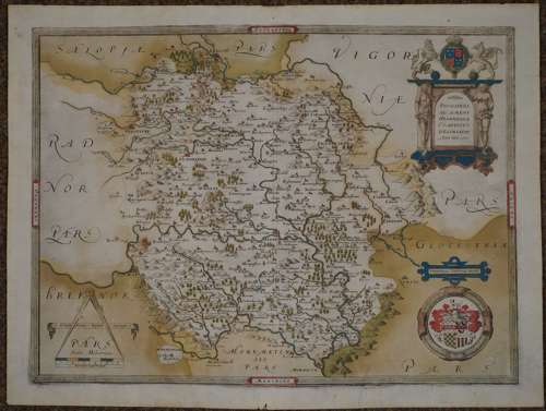
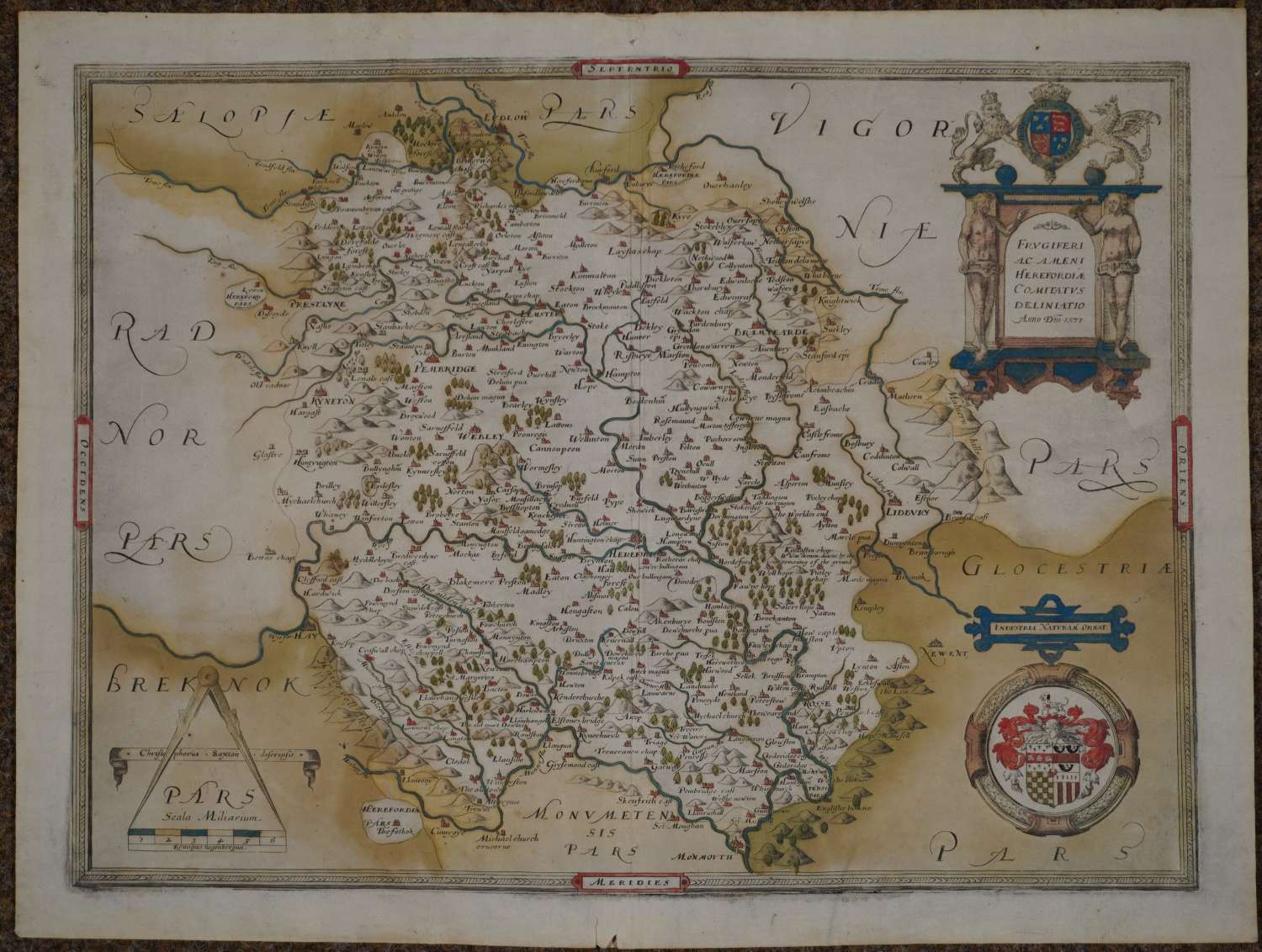
Copper engraving; original hand colouring. Bunch of grapes watermark . Without the latitude and longitude numerals inserted in the inside edge of the map and in the frame border (an edition of 1583 added the latitude and longitude numerals). Overall sheet size: 55.5cms x 41.9cms; image size: 499mm x 375mm. Arms of Thomas Seckford lower right (Saxton's paymaster and surveyor of the Court of Wards and Liveries of which Burghley was master). Royal coat of arms above title, flanked by the figures of Adam and Eve. Bottom left corner shows dividers bestride the scale bar, which bears the name of the great Flemish engraver, Remigius Hogenberg, behind which is displayed a scroll with points. On Burghley's own proof copy (held in the British Library) he and one of his secretaries wrote the names of the county gentry, including Cecil beside the place-name Alltyrynys, Skidmore (or Scudamore) of Kentchurch, Parry of Newcourt and Poston and Baskerville of Eardisley and Pontrilas. The king was concerned to know privately where throughout the country influential loyalist protestants and potential catholic dissidents had their homes. (Smith . Herefordshire maps p20) Unusually good margins (Saxtons are often cropped). Following continental precedents the site of the villages are marked by the conventional sign which was to become universal, a little open dot, which Saxton embellished with a church spire or tower. Hamlets are indicated by a square. In addition, the seats of the principal gentry were indicated by a circular fence to mark their deer parks, as at Eardisley, Holme Lacy and Newcourt in Bacton. Bridges are marked but not roads, a surprising omission to modern eyes, but Burghley was more concerned to learn the lie of the land, the situation of places and their relationship one to another than the routes between them. It names the valley of the river Dore as : The Gilden Vale, apparently the first published use of this name for the Golden Valley. It notes the landslip in 1575 on Marcle Hill; the spelling of place-names indicates sixteenth-century pronunciation, for example: Lemster (still the pronunciation of Leominster); Snowdell (Snodhill) etc Minute split at bottom of centrefold else in exceptional condition. A rare and important map.
Christopher Saxton was born in Yorkshire in the early 1540s and during his early life gained an enthusiasm for and understanding of map-making under the direction of a local vicar John Rudd, himself a cartographer.
During the reign of Elizabeth I it was William Cecil later to become Lord Burghley, who saw the national importance of effective maps to assist the administration and defence of the realm and with his enthusiasm and the patronage of Thomas Seckford an official in the Elizabethan court, Saxton was commissioned to survey the whole of England and Wales. This was a huge undertaking given the times and the means available to him. The survey began in the early 1570s and by 1574 the first plates had been engraved. By 1577 the whole of England was completed with the survey of Wales being completed the following year.
In the end the atlas comprised of a general map of England and Wales and 34 others of either individual or grouped counties. They were engraved by some of the best engravers of the time and when published they set a standard both in accuracy and decorative detail to the extent that they remained the basis for succeeding county maps for well over the following hundred years. They provide the earliest detailed picture of England and Wales and are a remarkable achievement.
----------------------------------------------------------------------------------------------------------------------------------------------------------------------------------------
1. 1579. Without the latitude and longitude numerals inserted in the inside edge of the map and in the frame border.
2. 1583. With the latitude and longitude numerals added.