Code: 54737
Date: 1676
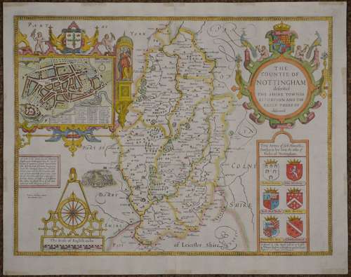
Long title: The Countie of Nottingham described The Shire Townes Situation and the Earls Ther Of observed. Copper engraving with later hand colour. Overall size : 55.2cms x 43.3cms. Image size : 507mm x 384mm. Latin text verso. Inset town plan of Nottingham. Scale of distance surmounted by compass rose and dividers. Title in decorative cartouche with six coats of arms below. The defeat of the supporters of Lambert Simnel in 1487 is noted by Speed . Two archival repairs bottom centrefold and bottom margin; old stains from old tape on margin edge on verso else good condition.
Until his late thirties, John Speed was a tailor by trade but his passion for history and map-making led him to gain a patron in Sir Fulke Greville, the poet and statesman, who found him a post in the customs and helped subsidize his map-making, giving him “full liberty to express the inclination of my mind”. He became aquainted with the publisher William Camden, whose descriptive text was used by Speed for most of the maps in his atlas “The Theatre of Empire of Great Britain” published most probably in 1612 although it bears the date 1611 on the main title page. The maps were engraved in Amsterdam by Jodocus Hondius, one of the foremost engravers of his time. Speed’s maps are unique historical documents of their time and the town plans featured on the maps are in most cases the first information we have of their early apppearance. Their artistry has guaranteed the collectability of these maps in the centuries that have followed.