
Code: 54865
Date: 1601
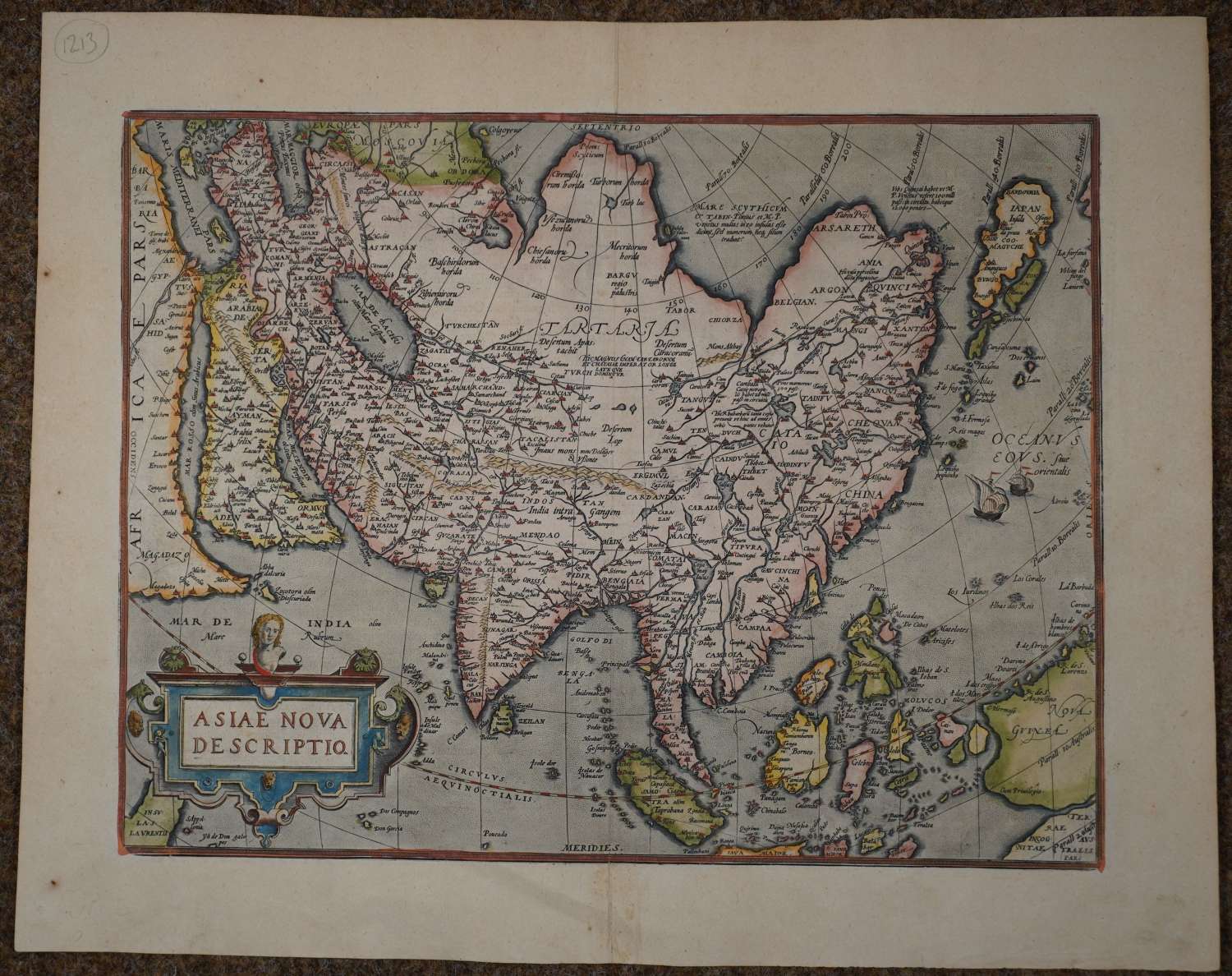
Copper engraving, original hand colouring, published by the Plantin press in Antwerp in the atlas "Theatrum Orbis Terrarum". Overall sheet size: 58.8cms x 47cms ; image size: 486mm x 375mm. It is the second of Ortelius’ maps of Asia - it has the lower case "Farfana" (top right) and the town "Ara" has disappeared. Villages and towns are indicated by large or small clusters or buildings with spires. Two sailing ships mid right and Australia makes an appearance, extreme bottom right ‘Terrae Incognitae Australes pars’ . The map is drawn on a cordiform projection. Japan and the adjacent coast of mainland Asia are located too far east. Part of New Guinea is shown, separated by a narrow strait from Terrae Australis. Ortelius based his map on his wall map of 1567, which was in turn was based on the work of Gastaldi and various other sources. This map was the standard map of Asia for more than forty years. The cordiform projection shows Asia extended too far to the east, an error carried on from Ptolemy. Japan is in a 'kite' form taken from Jesuit sources. Luzon is absent from the Philippines and the mythical lake Cayamay lacus is located in southern China. There are a great number of islands in the East Indies, but they are not well placed, due to the secrecy of voyages to the region, the information was not shared widely. Ortelius’ fine map of Asia depicts the continent at a time when Europeans were expanding their power in the Far East . Van den Broecke 7 The Ortelius scholar Marcel van den Broecke states that there were 200 examples of this map printed in 1601 (1st edition 1574). www. orteliusmaps.com
Abraham Ortelius, Flemish Abraham Ortels or Abraham Wortels, (born April 14, 1527, Antwerp [Belgium]—died July 4, 1598, Antwerp), Flemish cartographer and dealer in maps, books, and antiquities, who published the first modern atlas, Theatrum orbis terrarum (1570; “Theatre of the World”).
Trained as an engraver, Ortelius about 1554 set up his book and antiquary business. About 1560, under the influence of Gerardus Mercator, Ortelius became interested in mapmaking. Within a decade he compiled maps of the world on a heart-shaped projection (1564), of Egypt (1565), and of Asia (1567), as well as the first edition of the Theatrum, which contained 70 maps derived from 87 authorities and engraved in a uniform style. Enlarged and kept up to date in successive editions until late 1612, the Theatrum appears to have been the most popular atlas of its time. Ortelius was appointed geographer to Philip II of Spain (1575). Encyclopaedia Britannica.
