
Code: 55481
Date: 1662/1665
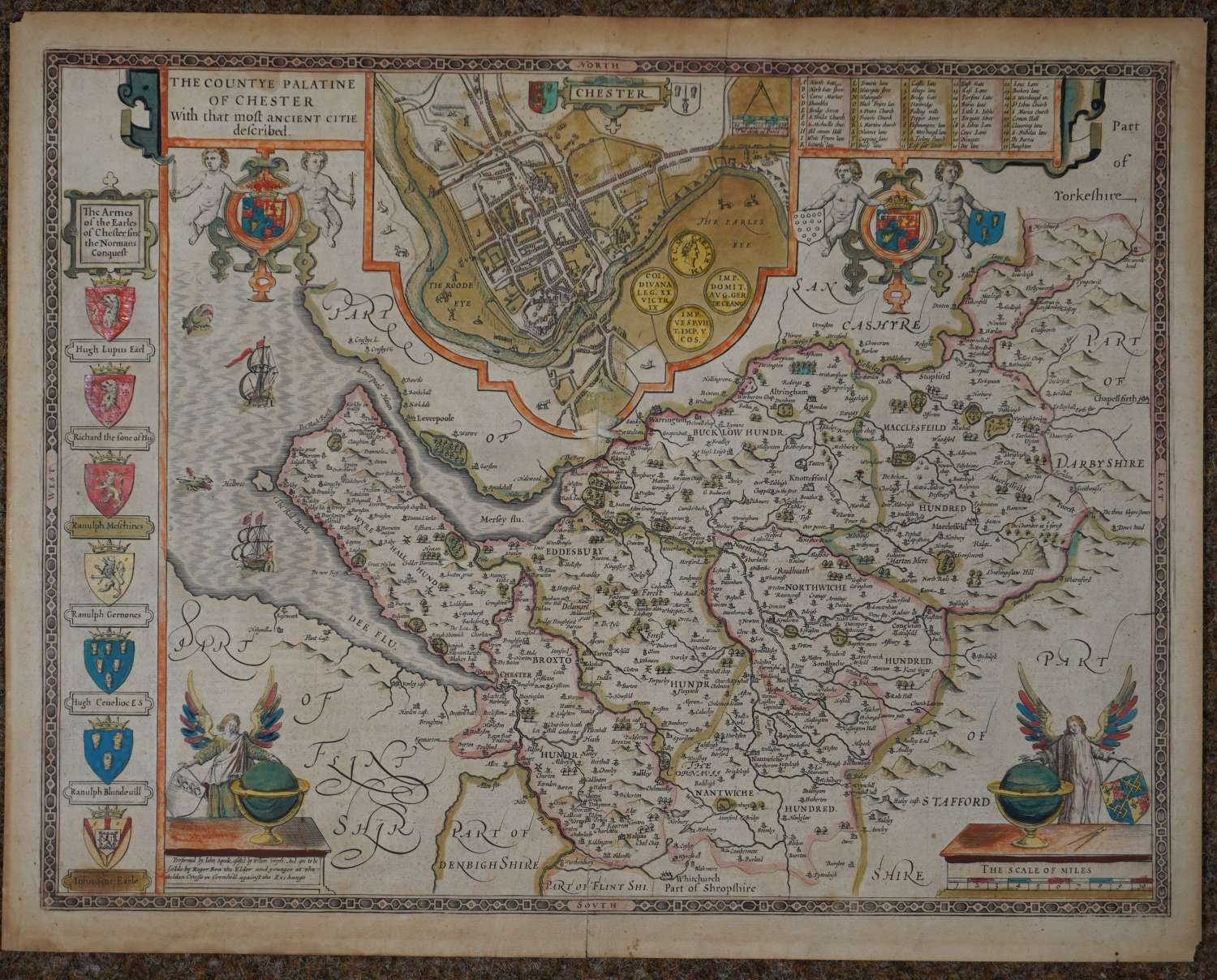
Rare. Copper engraving with ORIGINAL hand colouring. Overall size : 53.4cms x 42.3cms. Image size : 505mm x 384mm. English text verso describing the history and geography of the county. Inset plan of Chester and Armes of the Earles of Chester since the Normans Conquest. Four decorative cartouches. Speed has used William Smith's revisions of Saxton and the Braun & Hogenberg plan of Chester (the gallows continue to stand above the Earl's Eye (The Meadows) in Boughton on the right hand side). Angels and globes decorate the bottom right and left corners. Scale of distance at bottom right. Centre fold as published. Circular mark and three smaller dots in top margin and odd mark to right hand margin else very good condition. Overall toning especially in the margins, corner tops top left and bottom right missing and small abrasion at centrefold at the bottom of the central plan of Chester but good, strong impression in original condition with 5 cms split at centrefold from bottom margin, unrepaired with backstrip behind.
Until his late thirties, John Speed was a tailor by trade but his passion for history and map-making led him to gain a patron in Sir Fulke Greville, the poet and statesman, who found him a post in the customs and helped subsidize his map-making, giving him “full liberty to express the inclination of my mind”. He became acquainted with the publisher William Camden, whose descriptive text was used by Speed for most of the maps in his atlas “The Theatre of Empire of Great Britain” published most probably in 1612 although it bears the date 1611 on the main title page. The maps were engraved in Amsterdam by Jodocus Hondius, one of the foremost engravers of his time. Speed’s maps are unique historical documents and the town plans featured on the maps are in most cases the first information we have of their early appearance. Their artistry has guaranteed the collectability of these maps in the centuries that have followed.`
The map bears the imprint of Roger Rea the Elder and Younger. The Reas bought the rights to Speed’s work from William Garrett in 1659, who had previously purchased them from the widow of William Humble in the same year. Skelton suggests that the father and son intended a new edition of the atlas for the Restoration of 1660. However, the atlas would appear not to have been published until 1665. It is thought that many atlases and maps were destroyed in the Fire of London of 1666 and although there is evidence that the Reas planned to issue another atlas in 1666 and a few maps have been found with that date, in the end they sold the plates to Bassett and Chiswell who produced a successful edition of the Speed maps in 1676. The Rea maps are rare and good strong impressions.
