
Code: 55311
Date: 1611
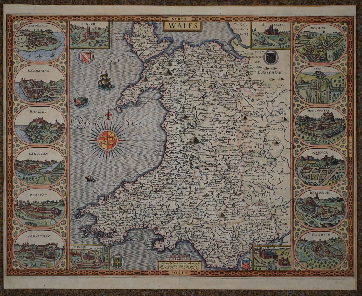
Copper engraving; later but not recent hand colouring . Woodcut initial by William Halland John Beale on verso. Overall size: 51.8cms x 41.8cms. Image size: 505mm x 383mm. Map flanked by 12 views of the principal towns (Beaumaris, Carnarvan, Harlieg, Cardigan, Penbrok, Carmarthen, Denbigh, Flint, Montgomery, Radnor, Brecknok, Cardife) and 4 views of the cathedrals (St Davids, Landafe, Bangor, St Asaph). Centre fold as published. As neither Saxton's atlas nor Camden's 'Britannia' contained a map of the country of Wales on its own, this is the first map of Wales to appear in a British atlas. With English text on the reverse.
The text on the verso describes ' the English call it Wales, as the people Welshmen, which is , strange and strangers ; for so at this day the dwellers of Tyroll in the higher Germany, whence our Saxons are said to have come, doe name the Italians (their next neighbour) a Welsh-man , and his language Welsh'. The map was probably engraved by Jodocus Hondius as the method by which the sea is shaded was introduced by him. Four armorials, a sailing ship, sea monsters and and an impressive compass rose bear the Arms of the Prince of Wales. Old strengthening to top of centrefold (9.5cms) and again (14.3cms) bottom centrefold not visible from the front. A rare map in good condition attractively coloured.
Unfortunately, there are no surviving records of how many examples of the First Edition (or indeed of any edition) were printed. One might speculate that the First Edition could have numbered between about five hundred and one thousand examples. It should be remembered that the market for maps was not well developed in England in 1612. This, together with the cost of the atlas, the need for a second edition soon afterwards, and the high quality of impressions from the third, Latin text, edition of 1616, suggests that the first print-run may have been closer to five hundred copies or so. Unfortunately, until an attempt is made at a census of surviving examples, these figures can be regarded as only the roughest of estimates. Ashley Baynton-Williams see http://www.mapforum.com/02/speed.htm
Until his late thirties, John Speed was a tailor by trade but his passion for history and map-making led him to gain a patron in Sir Fulke Greville, the poet and statesman, who found him a post in the customs and helped subsidize his map-making, giving him “full liberty to express the inclination of my mind”. He became acquainted with the publisher William Camden, whose descriptive text was used by Speed for most of the maps in his atlas “The Theatre of Empire of Great Britain” published most probably in 1612 although it bears the date 1611 on the main title page. The maps were engraved in Amsterdam by Jodocus Hondius, one of the foremost engravers of his time. Speed’s maps are unique historical documents of their time and the town plans featured on the maps are in most cases the first information we have of their early appearance. Their artistry has guaranteed the collectability of these maps in the centuries that have followed.
