Code: 54166
Date: 1855
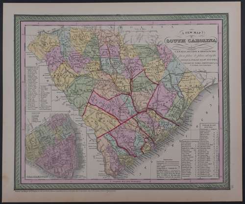
Long title: A New Map of Sth. Carolina with its Canals, Roads and Distances from place to place, along the Stage and Steam Boat Routes. Published 1855 in Pennsylvania, dated 1850 . Lithograph with original full wash hand colouring. Overall sheet size: 39.8cms x 33.1cms; image size: 358mm x 295mm including text. Characteristic green decorative border and pastel colouring. Bottom left quadrant shows a town plan of Charleston with Reference key to the most important places above and key to the Boroughs above the plan itself; Explanation key and Steam boat routes bottom right. Some browning to margins else very good condition.
Thomas, Cowperthwait & Co. were a publishing company based in Philadelphia. They were part of the burgeoning atlas and map publishing in the early to mid-nineteenth century. They published many famous works, including Tanner’s New Universal Atlas. Their maps are notable for the decorative borders and fine, vivid original hand colouring.