Mostlymaps |
Tel: +44 (0)1497 820539 Email: info@mostlymaps.com Web site: https://www.mostlymaps.com/ |
|
Code: 53663
Date: 1611
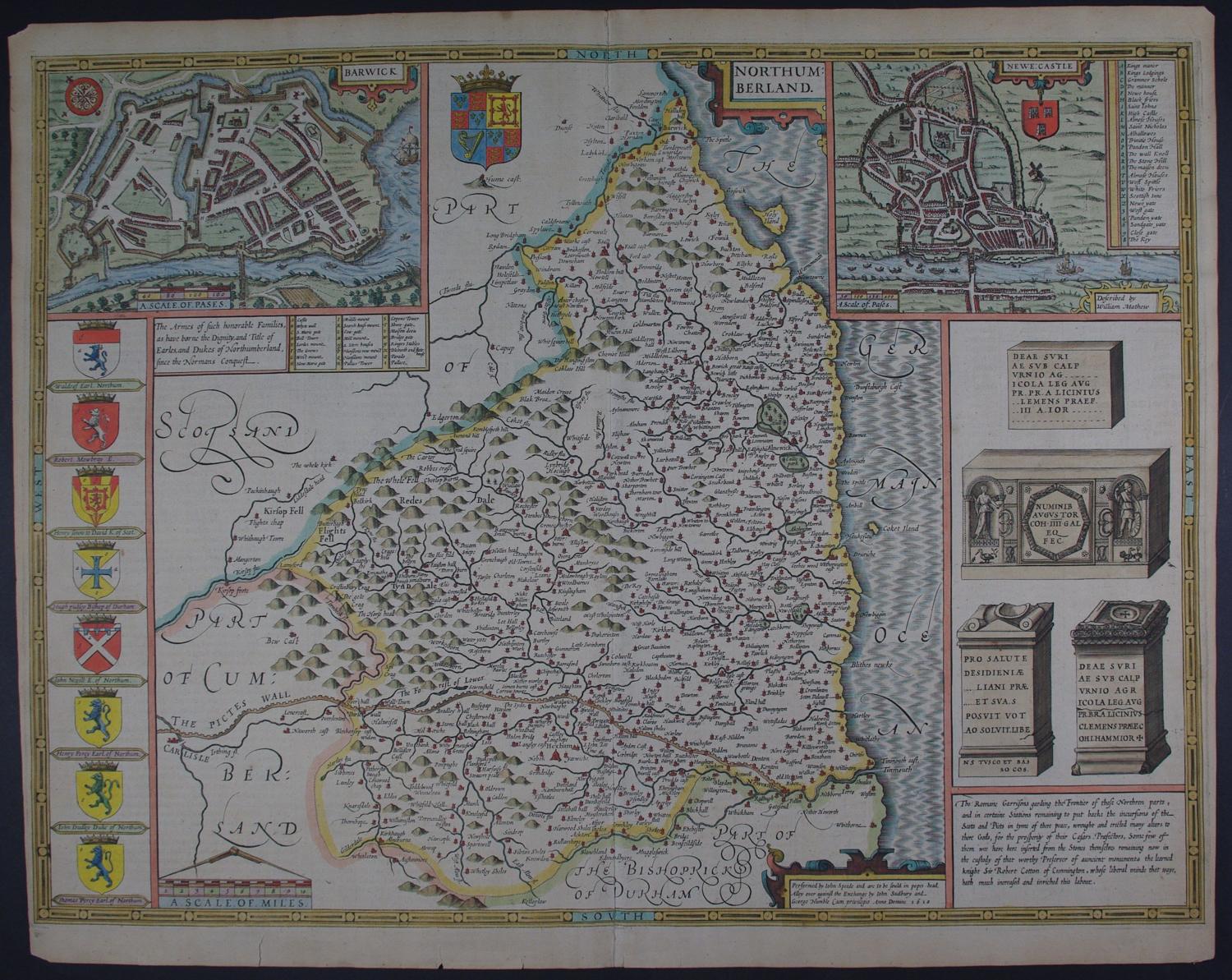
FIRST EDITION. English text on back of map describing the history and geography of the county. Copper engraving with later hand colouring. Overall size : 52.8cms x 42cms. Image size : 509mm x 380mm. Inset plans of Berwick and Newcastle (thought to have been surveyed by Speed himself). Hadrian’s wall isclearly depicted. Engravings of Roman ,. antiquities right hand side of map. Scale of distance surmounted by dividers. English text to verso. Centre fold as published. 2 edge tears bottom margin; possibly very slight separation 4.8 cms top centrefold but top right and left extreme margin tip missing; slight overall toning else very good condition indeed.
Unfortunately, there are no surviving records of how many examples of the First Edition (or indeed of any edition) were printed. One might speculate that the First Edition could have numbered between about five hundred and one thousand examples. It should be remembered that market for maps was not well developed in England in 1612. This, together with the cost of the atlas, the need for a second edition soon afterwards, and the high quality of impressions from the third, Latin text, edition of 1616, suggests that the first print-run may have been closer to five hundred copies or so. Unfortunately, until an attempt is made at a census of surviving examples, these figures can be regarded as only the roughest of estimates. Ashley Baynton-Williams see http://www.mapforum.com/02/speed.htm
Until his late thirties, John Speed was a tailor by trade but his passion for history and map-making led him to gain a patron in Sir Fulke Greville, the poet and statesman, who found him a post in the customs and helped subsidize his map-making, giving him “full liberty to express the inclination of my mind”. He became aquainted with the publisher William Camden, whose descriptive text was used by Speed for most of the maps in his atlas “The Theatre of Empire of Great Britain” published most probably in 1612 although it bears the date 1611 on the main title page. The maps were engraved in Amsterdam by Jodocus Hondius, one of the foremost engravers of his time. Speed’s maps are unique historical documents and the town plans featured on the maps are in most cases the first information we have of their early appearance. Their artistry has guaranteed the collectability of these maps in the centuries that have followed.`