Mostlymaps |
Tel: +44 (0)1497 820539 Email: info@mostlymaps.com Web site: https://www.mostlymaps.com/ |
|
Code: 54390
Date: 1675
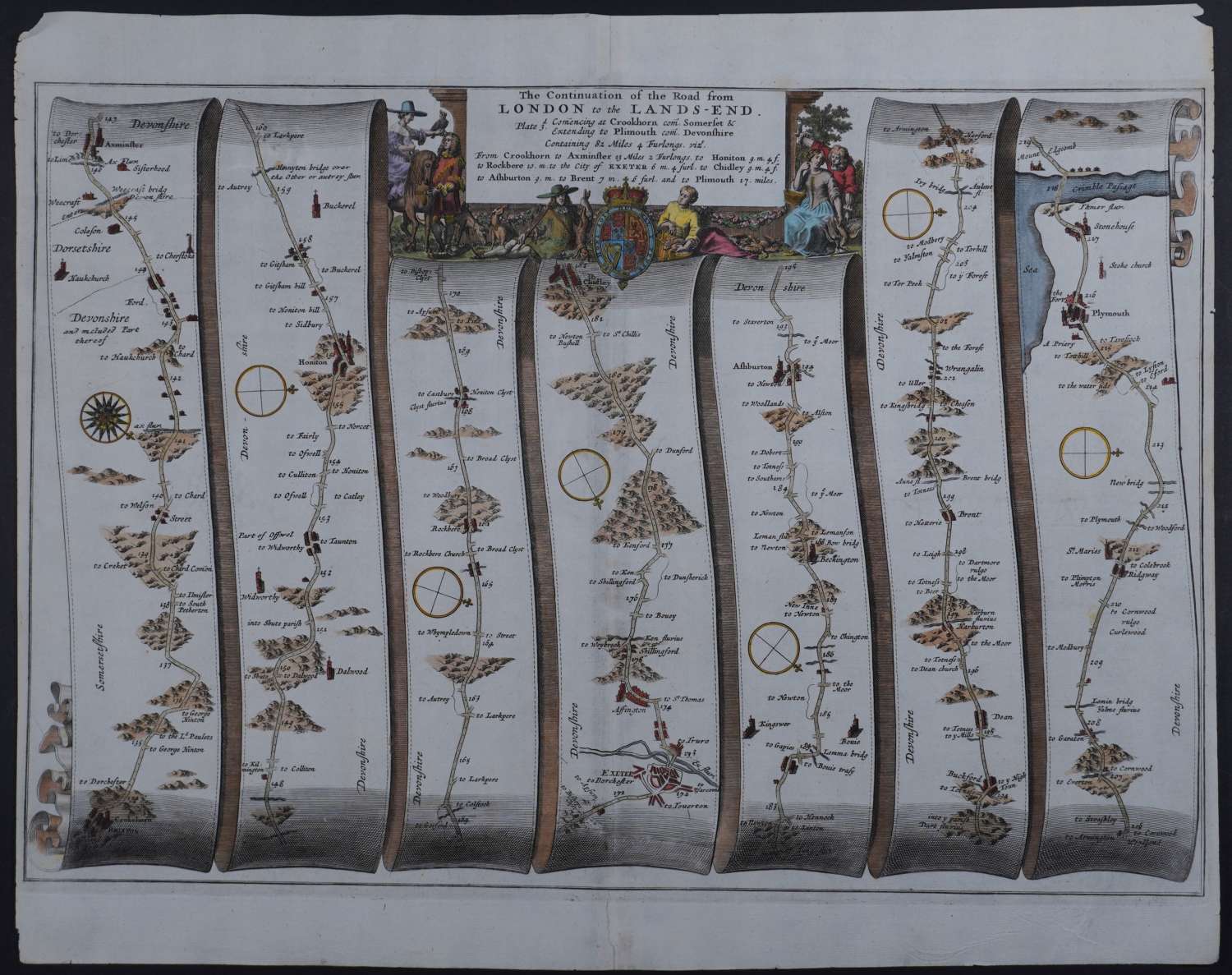
No 27. Long title:The Continuation of the road from London to Lands-End. Plate 3.
Commencing at Crookhorn, Somerset & extending to Plimouth, Devonshire. Containing 82 miles 4 furlongs. vizt.
From Crookhorn to Axminster 13 miles 2 furlongs. to Honiton 9m.4f. to Rockbere 10m. to the city of EXETER 6m.4f. to Chidley 9m.4f. to Ashburton 9m. to Brent 7m.6f. and to Plimouth 17 miles.Approx overall size : 49.2cms x 39.2cms. Copper engraving with good hand colouring. Highly attractive cartouche. The route is shown in seven strips, mile by mile, showing every town, village, wood and milestone along the way. Each strip has a compass rose showing north. Old repair top and bottom centrefold and repair on verso to top left corner on verso.
John Ogilby is regarded by many as the most important name in British Cartography after Christopher Saxton. He was born in Edinburgh in 1600 and led a varied life embracing many different careers. He started life as a dancing teacher and followed this with a spell as tutor to the children of the Earl of Stafford.
Next he went to Dublin where he ran a theatre successfully until the Civil War in 1641. He nearly lost his life in the Irish troubles and returned to London destitute. After a time in Cambridge as a literary translator he found favour at Court and was responsible for organising the coronation revels. After another sojourn in Dublin he set up business as a printer and publisher in London but this venture was destroyed in the Great Fire of London in 1666. After the fire he was appointed one of four "sworn viewers" who were ordered to survey those parts of the city that had been destroyed, in order to establish rights of ownership. The King appointed him Royal Cosmographer and Geographic Printer.
Encouraged by the King's interest in the project Ogilby began work on Britannia, the first national road atlas. The first edition of 100 strip maps appeared in 1675 funded in part by a lottery organised by Ogilby. Unfortunately Ogilby died in the year of publication and so the rest of the project was never completed. He established the Statute Mile of 1,760 yards as a national unit of measurement, prior to his work there were three different mile lengths in use.
See Reference works by J. Booth, R.A. Skelton and Thomas Chubb.
